
Years Two and Three - Post-Fire (2013 and 2014)
The Story of Plants, Part 1
The plants and rock outcrops are now as familiar and individual to me as family and friends and I'd like to introduce them to you. This post highlights plants I observed immediately after the fire. I'm indebted to Dr. Lee Frelich, forest ecologist at the University of Minnesota, and Lawson and Lynden Gerdes, retired ecologists with the Minnesota Biological Survey, for their insights and explanations.
What kind of landscape would replace the one just burned? According to Lawson Gerdes, the landscape before the fire was likely an FDn32 (Fire-Dependent Forest/Woodland System Northern Poor Dry-Mesic Mixed Woodland). The Field Guide to the Native Plant Communities of Minnesota, The Laurentian Mixed Forest Province says FDn32 includes pine and black spruce woodlands with paper birch and quaking aspen growing on the nutrient-poor shallow soils over the bedrock outcrops. Shrubs such as juneberries (Amelanchier spp.), low-bush blueberry (Vaccinium augustifolium) and bush honeysuckle (Diervilla lonicera) would be prevalent.
Historic fire maps show that the last severe fire in the area was over 100 years ago, so this would've been a mature woodland. As the average rotation of catastrophic and severe surface fires is estimated to be 100 years, the forest was ready for replacement.
I employed the Field Guide and a plant list generated by Gerdes with forbs and grasses to clue me in.

Visiting the fire area, I often stayed nearby at National Forest Lodge in Isabella, Minnesota in a cabin affectionately known as Big Pines Shorty. The kitchen table was my work station for online plants research and verification before and after heading into the field. Fortunately, there was good cell phone reception!
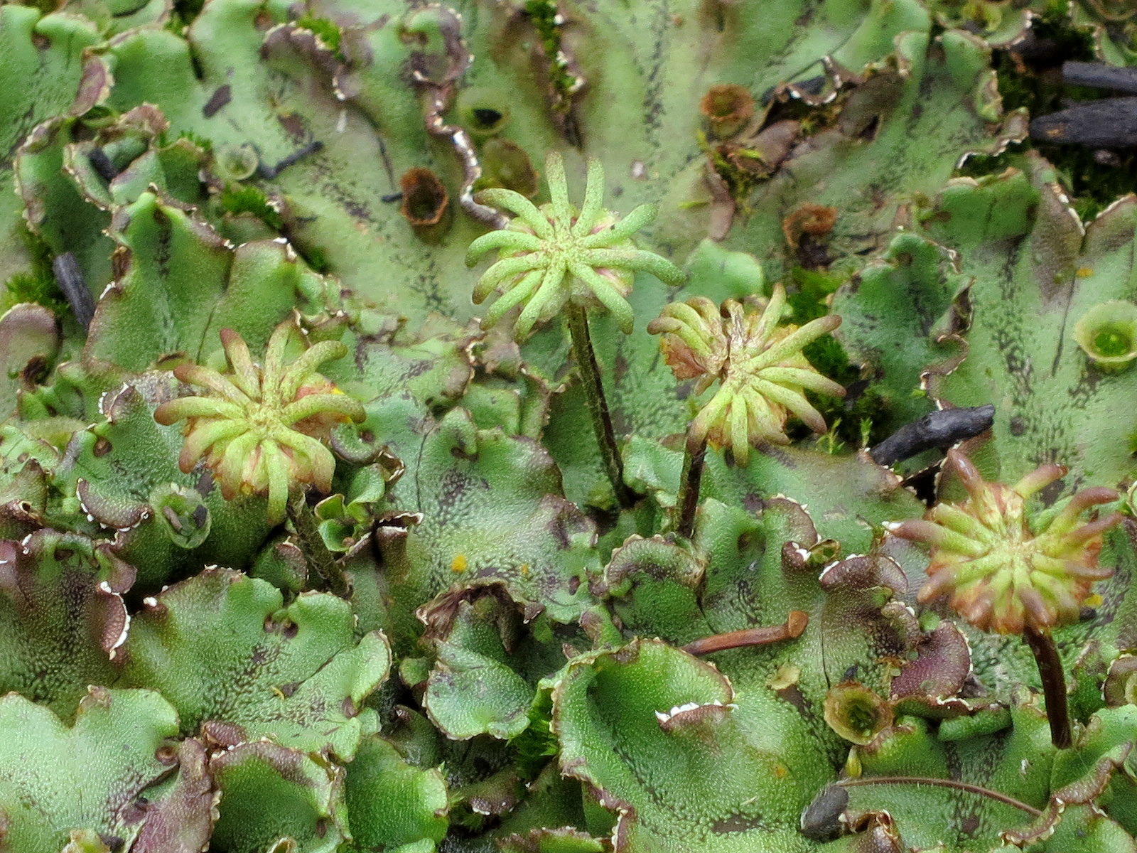
In May 2012, less that six months after the fire, Lawson Gerdes led me to the fire area location on Island River recommended by Dr. Frelich. Bryophytes (mosses and liverworts) were the first colonizers carpeting the bare ground, thriving on the burst of available nitrogen. They have fabulous forms, shapes and textures. By fall of that first year post-fire, grasses and sedges sprouted and pink Fireweed (Epilobium augustifolium) bloomed among the bryophytes.
Site #2b during my second visit, September 2012. Fleshy bryophytes carpet the ground

The following two years marked the greatest change in the landscape.
Field Notebook, September 12, 2013
The day is moody with crystalline blue sky punctuated by linear, fluffy clouds stacked to the horizon, alternating with dull, somber gray masses that block out the sun.

After two growing seasons, the landscape is evolving. I can’t say it’s recovering; but rather it’s changing in profound ways. As the burned trees collapse or blow over, the soil is disturbed and a great network of potholes has formed. With the prevalent rains, the hillsides erode and are sliding down into Island River. A large, wide bench of spongy moss and bryophytes (mosses and liverworts) are forming at the edge of Island River on the soil washed down the hillside. This edge is rich with sprouting sedges, cattail, bulrushes, irises and shrubs and quite visually arresting.
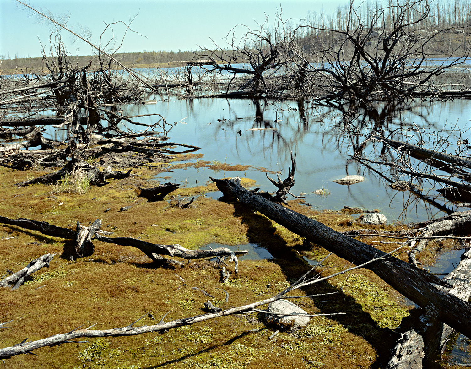

This edge is a transition zone – but not especially interesting to ecologists – it is not a clear enough example of one forest type or another. It is a mixed blend of plants that may have resulted from seed material blowing in; or having been released from the existing seed bed; or carried down the hillside; floated in; deposited by birds or animals; or suckered from existing trees or shrubs. Too many variables are causing this landscape to form and re-form.
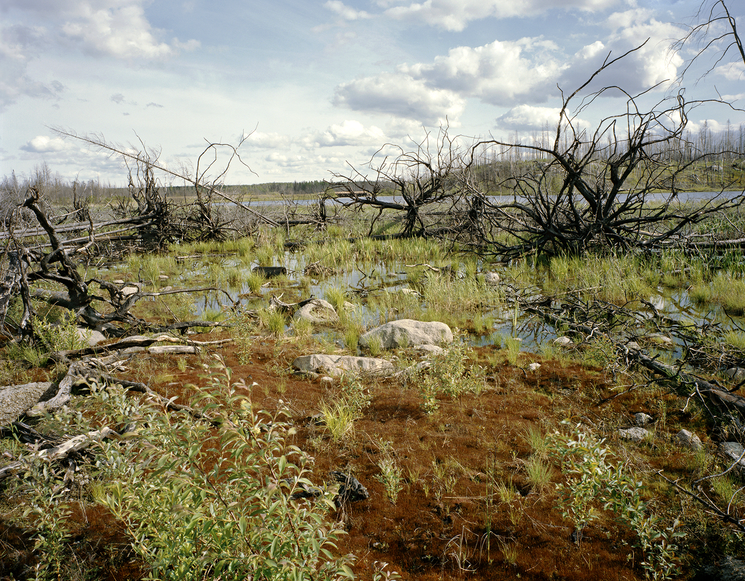
On the uplands, a webby net of sprawling Fallopia vines, now reddish after a frost, covers the downed trees, boulders and bare soil. Walking is treacherous; the vines catch on my boots, tripping me. They obscure the potholes and downed limbs. Other plants, shrubs and tree seedlings are having a difficult time competing with this vine. I wonder how prevalent Fallopia is in the burn zone and whether it’s an invasive that will inhibit other plants.
Site #2a on south-facing hillside. Fallopia vine spreads its net over the landscape
With these changes, some of the compositions at several sites have disappeared as trees fall down and vegetation, including the disgusting vine takes over. The quality of the vegetation is mixed. Fireweed, Jack pine seedlings, Bush honeysuckle and other shrubs, grassy plants, and in some cases ferns struggle to compete with the vines. What this landscape will become is difficult to perceive. A messy sorting process is going on.
Houghton's sedge (Carex houghtoniana) was found at both Sites #2a and #2b, a south-facing upland slope; but was common throughout the Island River burn area. I carried dog-eared pictures of my locations and they came in handy for connecting plants with their settings.
Field Notebook, June 7, 2014
Light rain was falling when I awoke, but the sky cleared around 10:30 am and I headed for my sites in the fire zone. The light is delicate and diffuse after the rain and the plants appear luscious; raindrops still cling to the fireweed. I work mostly with color film, using the Hasselblad with the wide-angle lens close to the ground on a short tripod. Later in the afternoon, around 4:30 pm, I switch to the 4x5 field camera and use the wide-angle lens.
I find the hillside blanketed with
Trees and Shrubs –
Populus tremuloides, Trembling aspen
Pinus strobus, White pine
Pinus banksiana, Jack pine
Picea glauca, White spruce
Picea mariana, Black spruce
Diervilla lonicera, Bush honeysuckle
Cornus rugosa, Round-leaved dogwood
Plants –
Bryophytes including Funaria grometrica, Lungwort
Epilobium augustifolium, Fireweed
Carex houghtoniana, Houghton’s sedge
Fragaria virginiana, Common strawberry
Rosa spp.
Aster macrophyllus (or Eurybia maculata?), Large-leaved aster
Geranium bicknelli, Bicknell’s cranesbill
Fern spp. on southwest-facing slopes
Rubus strigosus, Red raspberry
Vaccinium augustifolium, Lowbush blueberry
Corylus americana, Hazelnut
Cornus canadensis, Bunchberry
Aralia nudicans, Wild sasparilla
Viola spp.
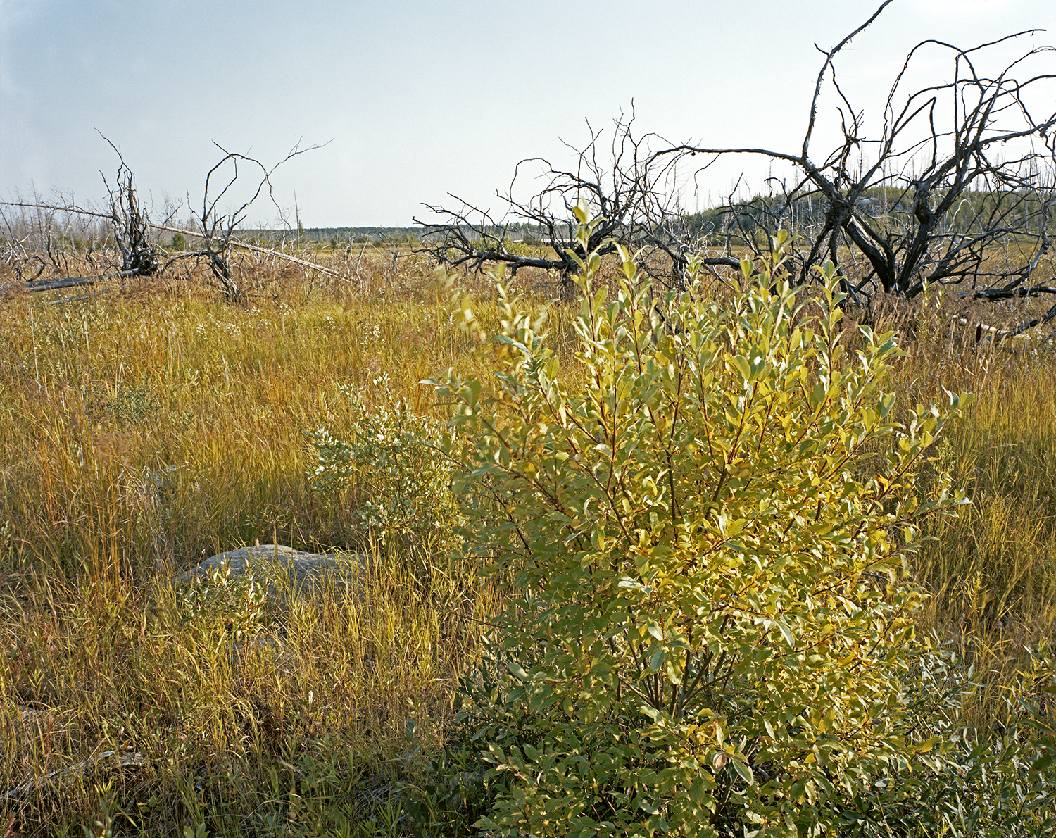
Site #2b during June 2014 visit. Bryophytes, Willow (Salix spp.), Fireweed (Epilobium augustifolium), Red raspberry (Rubus var. strigosus), Large-leaved aster (Aster macrophyllus) and two-foot-tall Black spruce (Picea mariana)
Is the landscape becoming what it was – FDn32 – or becoming something else? The first colonizers were the bryophytes (mosses and lungworts) and they still form an under-layer, beneath the fireweed and other plants. At this point, the ground layer is dominant and shrubs and sedges are coming on strong. Scattered tree seedlings of White pine, Jack pine, and White and Black spruce are about two-feet tall.
To be continued...

